What is Taxicab Geometry?
Taxicab geometry is named after the familiar taxicab, navigating the streets of a typical 19th century city. Many cities built their road system around a grid, where streets run north to south or east to west. In order to get from point A to point B, a taxicab can’t travel “as the crow flies” but rather has to navigate the square gridded streets. This forced pattern (around the edges of squares) usually results in longer distances. 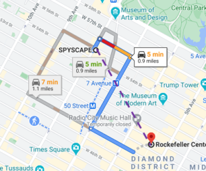
Why is Taxicab Geometry Non-Euclidean?
Euclidean geometry is based on Euclid’s axioms. One of these states that the shortest distance from A to B is a straight line. In order to calculate that straight line, we use the distance formula, based on the Pythagorean theorem: the square root of (x2 – x1)2 + (y2 – y1)2. In the above map of Manhattan, the shortest distance from Skyscape to Rockefeller Center is the purple dashed line. However, taxicabs can’t travel through blocks—they must drive around their perimeters. We can’t use the distance formula as that would require a taxi to drive through buildings; Therefore, the “shortest line” axiom is violated.
The Distance Formula
The distance formula in taxicab geometry looks a little different, but it’s surprisingly simple to work: |y1 – y2| + |x1 – x2|. Let’s say you wanted to find the shortest distance between points (2, 8) and (4, 4). Inserting our x- and y-values into the formula, we get: |8 – 4| + |2 – 4| = 4 + 2 = 6. Graphically, we can easily verify this result: 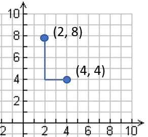
Circles in Taxicab Geometry
The definition of a circle is a shape where all points on the boundary (i.e. the radii) are equidistant from a fixed point (the center). In Euclidean geometry, that definition gives us a familiar round shape. However, a circle in taxicab geometry looks very different. In the following image, the points on the boundary (blue) are all 3 units away from the red central point. Some of the possible paths are shown in blue: 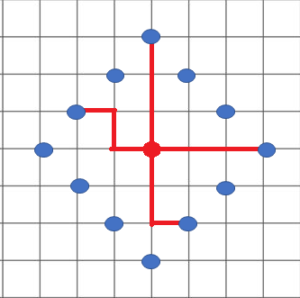
References
Moscovich, I. (2004). The Monty Hall Problem and Other Puzzles. Sterling.